

Franz Josef and South Westland has a long and colour history, in fact Abel Tasman and James Cook saw the mountains of the region from their ships!
A quick time line of the area looks like this…
- 1846 Thomas Brunner walked from Nelson to Paringa and back.
- 1860’s Julius von Haast from Germany named the Haast Pass and the glacier after the Emperor of Austria Franz Josef.
- 1864 beginning of gold rush especially on the coast and land clearance for sawmilling and farming.
- 1890’s Charlie Douglas explores South Westland; beginning of tourism.
- 1911 first car drives from Hokitika to Franz Josef.
- 1920’s Graham family provide tourist and mountaineering services.
- 1965 opening of Haast Pass route.
South Westland was well known to the early Maori people who travelled through in search of Pounamu (greenstone) while recent archaeological work has shown that there were a number of small settlements along the coastline near important food sources, such as Okarito Lagoon. In the l7th and l8th centuries the navigators, Abel Tasman and James Cook sailed along the coast and noted the high mountains. Later, sealers and whalers came to exploit the coastal areas.
In 1842 Thomas Brunner and Maori guides made an epic journey on foot from Nelson, he and other later explorers came in search of farmland but only found rugged bush and mountains instead!
The discovery of gold in 1865 in the area saw an influx of people and the development of ports, roads, services and communities. In South Westland the richest claims were on the beaches but miners also worked inland including in the vicinity of Franz Josef township. The boom and bust nature of the gold days meant that the large coastal towns slowly dwindled and little remain today. Some miners returned to farming and began the difficult task of clearing the forest to sow pastures. Even at the turn of the century South Westland was a remote area, the roads being merely tracks with many dangerous rivers to be forded.
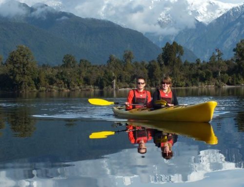
Despite the difficulties of travel, spectacular glaciers set in lush rainforest attracted tourists and early accommodation was often in the homes of local people, however as the visitor flow increased hotels were built while scenic reserves were established to protect the glaciers and main lakes as early as 1910.
In 1965 the Haast Pass road was completed which enabled travellers to make a round trip incorporating the park.
In December 1990, 2.6 million hectares of South-West New Zealand was declared a World Heritage Area which gave international recognition to the outstanding natural values of the area (known to Maori as Te Wahipounamu, the place of the greenstone). The World Heritage Area incorporates Fiordland, Mt Aspiring, Westland and Mt Cook National Parks plus neighbouring protected areas.
Westland National Park
In the 1920’s scenic reserves were created to protect the majestic glaciers while the park was created in 1960 and stretched west of the road to the top of the divide. In 1982 it was extended to the coastline to form a `Mountains to Sea’ park.
Franz Josef Fox Glacier Region
Over 13,000 years ago during the last ice-age, ice-sheets extended over the lowlands and into the sea. Temperatures were at least 4 degrees Celcius cooler than at present!
Other interesting highlights and useful information include…
- The formation of Lake Wombat over 9,000 years ago when a big block of ice melted.
- Around 1750 (during the ‘little ice-age) moraines in the Douglas Bridge area were deposited.
- The glacier terminal was over Sentinel Rock in the 1890’s and at the present car park as recently as about 1920.
- The glacier road was extended further up the valley prior to I984 when a big flood washed it out.
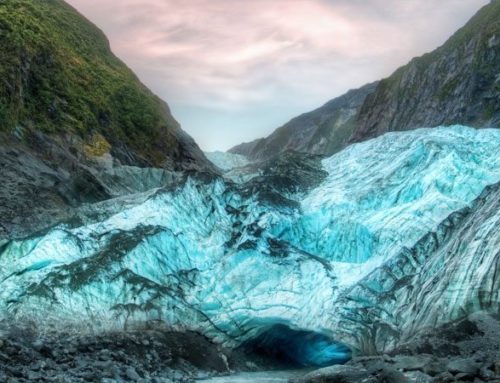
- Successive layers of snow are compressed into hard ice in the Neve and the glacier begins to flow down-valley (because of gravity) like a ‘river of ice’. The uneven valley floor and movement causes crevasses and pinnacles (seracs) to form.
- The rate of ice flow depends on the steepness of valley.
- The Franz Josef Glacier takes about five years for ice to flow from neve to terminal while Fox Glacier takes about seven years.
- Flow rate has been measured several times this century; results do conflict but the average suggests the ice moves 2 to 3 metres at the fastest point (in the steepest part of the ice-fall). Ice keeps on flowing down-valley regardless of whether the glacier is advancing or retreating.
- Advance/Retreat is caused by the balance between accumulation of snow in the neve and melting. Meaning, if accumulation exceeds melting = advance, however if melting exceeds accumulation = retreat.
- Since the last ice-age the glaciers have generally retreated, but there have been several big advances. These are usually caused by extra snow falling in the neve on a short term basis.
- Baumann snowfield is about 6000 feet above sea level between Mts Moltke and Roon (7325 ft).
- The vivid blueness colour in ice is thought to be caused by refraction (bending of light as it passes through ice crystals).
- Franz Josef was named by Julius von Haast (geologist and explorer) after his Austrian Emperor. Fox was named after William Fox, Premier of New Zealand in the 1860’s. Haast was the first to explore the terminal of the Franz in the 1860’s, but the area was not fully surveyed until Charlie Douglas did so in the 1890’s.
- Mt Cook was first climbed by three New Zealanders: Tom Fyfe, Jack Clarke and George Graham on Christmas Day 1894.
- Mt Tasman was first climbed by Englishman E.A. Fitzgerald and his Swiss guide M. Zurbriggen in 1895.
- Goods views of Mount Cook and Tasman can be seen from Waiho Flats Road.
Names of Peaks
Looking south down the main road, the Fritz Range is visible (named after German Kaiser) while the snowy dome located on the left is Bismarck Peak and on right Mount Roon. There are many Germanic names after early climbers in the European Alps.
Geology
New Zealand’s main geological feature, the Alpine Fault, runs along the base of the mountains more or less through the villages of Franz Josef and Fox. The western plate is pushing underneath the eastern plate causing the mountains to uplift at one centimetre per year.
Weather
Water laden clouds from the Tasman Sea moving eastwards are slowed by the mountains causing heavy rainfall.
Franz Josef can receive approximately 5000mm on about 170 rain days. While Christchurch receives approximately 650mm on about 90 rain days.
Glaciers
Successive layers of snow are compressed into hard ice in the neve (snow basin). The glacier begins to flow down the valley (because of gravity) like a ‘river of ice’, while the uneven valley floor and movement causes crevasses and pinnacles to form. It takes five years for ice in the Franz Josef Glacier to flow from neve to terminal.
If there is more accumulation of snow than melting ice the glacier will advance (and vice versa). Since the last ice age approximately 14,000 years ago, increasing temperatures have caused glaciers to retreat.
Forests
Temperate rainforest (ie: forest caused by high rainfall and a temperate climate) only grows in three places in the world… here on the West Coast of New Zealand, West U.S.A. and South Chile.

Leave A Comment